
Yarm……….
did you know?
Yarm is over thirteen centuries old, and possibly older still, and therefore not surprising that the name of the town has changed considerably through the ages.
In the Domesday Book we find it written as Larun, and in various charters and grants after the Conquest, the place is differently noted as Gerou, Yareham, Yareholm, Yarome, Yarme, Garum, Jarrom, Yarrum, Yharum, Gearum and Jarum.
The name is thought to imply a sheltered place although its Saxon origins could also mean simply “habitation near water’. The Old English ‘Gearum’ denotes ‘fish pools’.
You choose.
It is almost certain that a clan of Iron Age Celts known as Brigantes fished the river Tees round the peninsular of Yarm on which their huts stood, grew corn on the flatts to the west, and grazed their cattle on the higher land to the south. The main evidence of a British settlement comes from Yarm’s only prehistoric find. When excavating for the foundations of the Iron Bridge in 1804, some workmen found an ancient canoe about 23 feet long, carved out of a tree trunk, several feet below the present river bank level. A few feet lower down, at rock level and in what was doubtless an old rubbish pit, they discovered the horns, skull and other bones of a stag, the horn of a wild ox, and a rude iron horse-shoe which must have got there by accident. All these remains were in a state of good preservation although there is no record of what became of them. As the Iron Age began in this country about 600BC the horse-shoe establishes the date a little later.
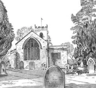
The Church of St. Mary Magdelene stands on the west side of Yarm and includes a now disused churchyard between West Street and the river Tees. There has been a church on this site since the seventh century. All that remains of the first stone church are the west end except for the tower, several carved fragments preserved in the vestry and some stones built into the churchyard wall. The west end however is old with the lower part being Norman. Most of the old stone church was destroyed by fire in 1728 and rebuilt in 1730 (in a pseudo-classic style) as the weather vane on the tower reminds us.
The interior of the church was restored in 1878 when the west end organ gallery was removed, the chancel extended and the organ re-housed at the east end of the north aisle. The Moses window was removed from the east end to the south aisle and the present east end window was installed. A new pulpit was substituted for the earlier one of Grecian design with a sounding board supported on a Corinthian column, and all the seating replaced by oak pews. The total cost of this work was £2,302.
When entering the church you will find an interesting feature; it is a table tomb cover near the west wall and just inside the door porch. This stone slab, which is let into the flooring, has two carved recumbent male and female figures; the size and clothing indicate that the monument was early fourteenth century work. Legend has it that these two figures depict the original “True Lovers” after whom True Lovers Walk was eventually named.
Early references to Yarm are to be found in William Camden’s “Britannia”, produced in 1586. Here we are told that Yarm was famous for its market, that Bishop Walter Skirlaw built a bridge over the river Tees in about 1400 and that the town had an ancient hospital. The town consisted of one large street running north and south and several times suffered severely from floods owing to the lowness of its site. Flour, cheese and bacon were within a list of exports and mention is made of the wealth of fish, particularly salmon in the river.
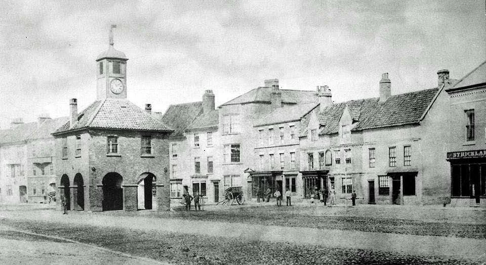
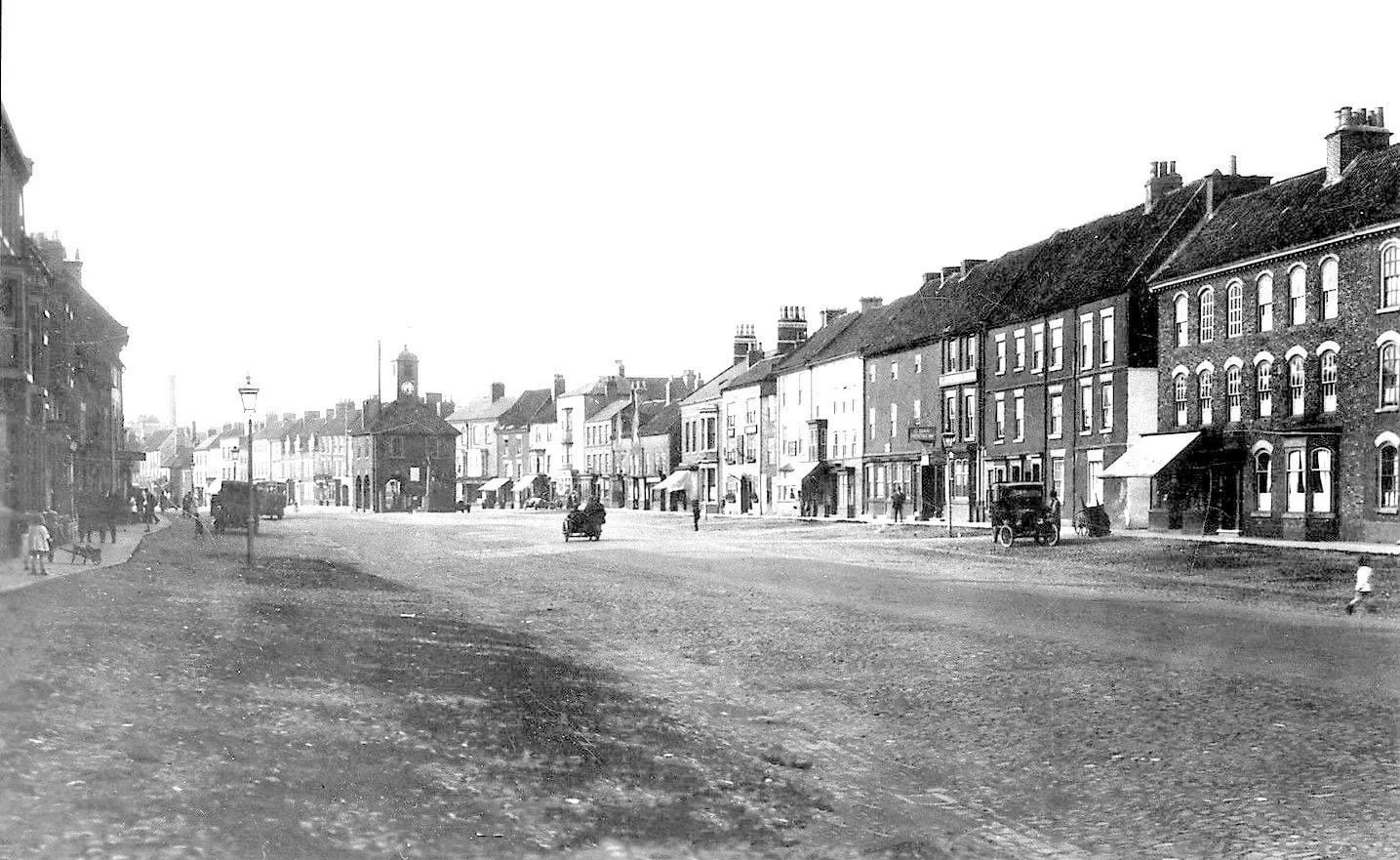
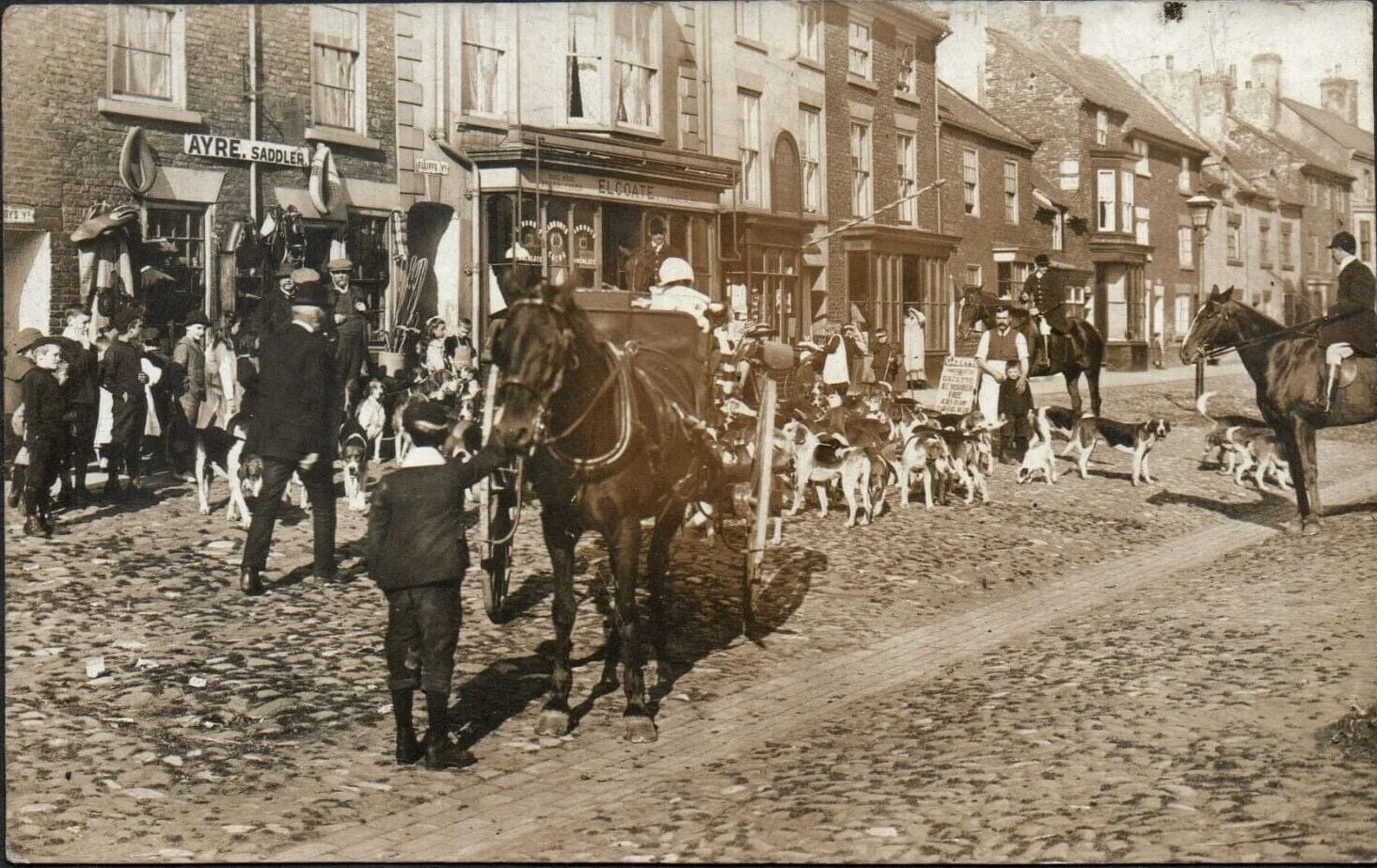
The High Street with which the town began was called King’s Street in mediaeval times and Town Street much later. Between the pavements at each side and the tarmacadamed roadway the wide street surface is paved with cobble stones. These cobble stones were a bone of contention in 1950 between the Parish Council and the County Council the latter wishing to replace the cobbles with concrete and tarmac so as to provide parking for road vehicles which were damaging the present surface.
It would seem that cars, cobbles and parking have been the subject of much debate and discussion throughout the decades since.
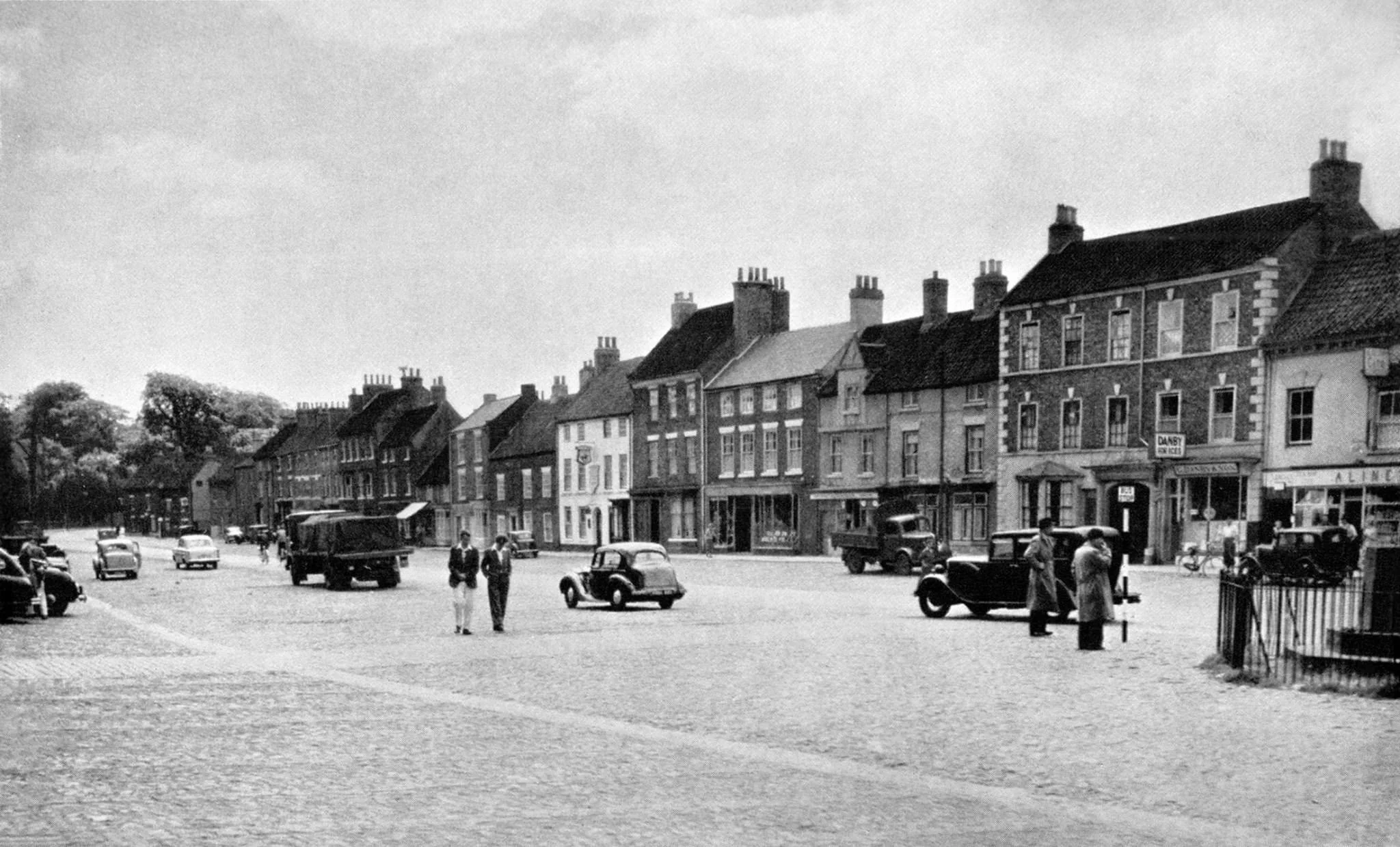
From the east side of the High Street, five narrow streets run to the riverside path. These, from north to south, are Silver Street, Chapel Wynd, Central Street (formerly Chapel Wynd), Mill Wynd and Atlas Wynd. Each is lined with houses, cottages, gardens…. and warehouses which have either disappeared or recently converted for commercial or residential use. The old Methodist Chapel and the Parish Church Hall are in Chapel Wynd and the Lord of the Manor’s water-mill used to stand on the river bank near by. When Yarm was a port there were wharves all the way from Central Street to Atlas Wynd backed by a long line of warehouses known as East Row.
From the west side of the High Street, one wide and three narrow streets run to West Street and these from north to south are Bridge Street, Low Church Wynd, High Church Wynd and Bentley Wynd. The second, which was also called Champneys Wynd in the Middle Ages and Cross Wynd later, is mainly a narrow lane between garden walls and from which is a path - along the east side of the viaduct and on the site of the old town ditch - connecting with High Church Wynd. When Yarm engaged in the weaving industry this was carried on in Bridge Street, which was then called Flapper Street because of the cloth being beaten there. The old fire station is at the north-west end of this street and to the east of it - across a lane leading to the river - are the house and garden which were once a Quaker meeting-house and burial ground.
Church Wynd, which was earlier called Kirkgate, Kirk Wynd and Church Wynd accommodated a drill-hall for the Green Howard’s and an infants’ school towards the south end. In more recent times many of us will remember the Police Station too.
West Street, which in earlier days was called Westgate and later Back Street, runs parallel with the High Street and to the west of the viaduct. On the east side there was a road transport goods yard with depot behind, a local gas office with a small pressure-regulating gas-holder in the adjoining yard. West Street is now predominantly houses and cottages although the transport building remains and currently being used to incorporate a Marshall Arts centre.
Incidentally, except for Richmond in Swaledale, Yarm is the most southerly place in Great Britain to use the Scottish name of Wynd (pronounced “weend”) for a narrow lane.
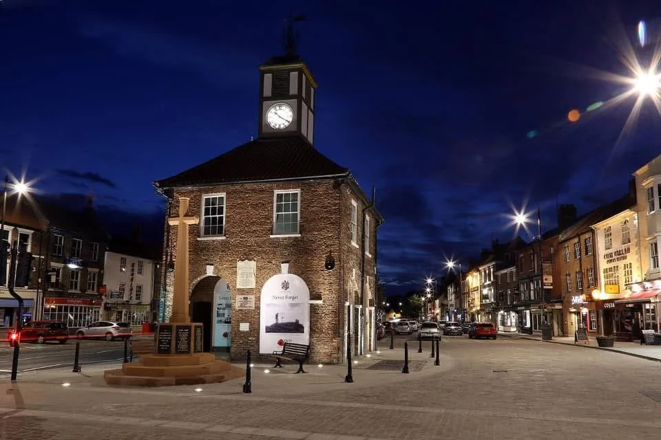
The Town Hall stands in the middle of the High Street like an island in the river, a feature common to the market towns of the old North Riding, and it was erected in 1710 by the Lord of the Manor as a Court House in place of the ruinous Tollbooth. Later is was used by local magistrates for petty sessions and then, until recently, the meeting place of the Parish Council. In January 2024, following a major refurbishment, Yarm Town Hall’s Heritage Centre officially opened its doors showcasing ‘Island in a River’, a permanent exhibition celebrating Yarm’s ancient connection to the River Tees and offering a collection of historic local artefacts. Central to the exhibition is a replica Iron Age canoe, carved by local volunteers from Friends of True Lovers group,
The Great Flood of 1771
On Saturday night, 16th November 1771, there was the greatest flood in the River Tees that was ever known in the memory of man. The flood at Stockton, though greater than ever remembered, did not do much damage. One warehouse and two or three cellars with liquor were under water. As soon as the flood was discovered at Stockton, carriages were procured to take two boats overland to Yarm, with some experienced sailors, who thereby, saved the lives of many.
It had begun to rain in Yarm very early that Saturday morning and continued without intermission all that day. The Rev. Bramwell, to whom the inhabitants of that town were under the greatest obligations for the many times he had furnished them with timely intelligence, and more especially this flood, when, at the hazard of his life, he ventured home, being then in Yarm, riding for several hundred yards with the water up to the axle of his carriage wheels. He sent off an express from Hurworth, which arrived at Yarm between 8 and 9 o'clock that night, and informed the town that the water was higher at Hurworth when he came away than it had been for some years and would be very high here about 3 o'clock on the Sunday morning but as it grew very fast when he left the place, there was no ascertaining how high. This message occasioned the inhabitants to remove their goods.
The Cross Bell was rung, that every one might be alarmed, but as the water was at the arrival of the messenger not much above the quays, no person seemed to be in any hurry as it had so much to rise before it could do any damage in the town. They were deceived however, for it increased so fast upon them that several were obliged to quit their shops and warehouses, before they had got their goods sufficiently secured, in order to save their own lives. Some narrowly escaped being swept away in endeavouring to reach their dwelling houses.
Sunday morning discovered a most dreadful scene All the town, not so much as a single house excepted, lay under water. The arches of the bridge were quite full, so that the water made its way over the battlements and the greatest part being driven back with a dreadful torrent down the west side of the town, swept almost everything away which opposed its force.
All the garden walls from Flapper Street to Bentley Wynd, to the number of near 69, were thrown down, as also a dwelling house, happily no one in it, opposite to Mr. Hartley's in the same street. Whose house must likewise inevitably have shared the same fate had it not been remarkably strong. The court wall before his house, with the gates and part of his garden wall, were swept away. A great deal of the garden wall at the Friarage, belonging to Edward Meynell, was gone and the garden almost ruined.
Yarm church also suffered greatly, all the pews from the north and south aisles were turned bottom up. The pulpit in it was thrown with its top upon the steps going to the communion table and several of the windows broken to pieces. A beautiful little organ was quite spoiled. The water in the church was about three yards deep.
The main street was a picture of ruin and devastation, six dwelling houses were entirely demolished and many more rendered uninhabitable. There were seven persons drowned and one of the bodies missing. In one house where there were three people, two were drowned and the other was saved by hanging 19 hours up to the chin in water by the top of a window.
At the low end of the town a weaver, who was a good swimmer, saved the lives of many. On the Sunday morning before daylight he hearing the cries of many people, who seemed to be drowning, courageously leaped out of his chamber window and swimming to the chamber windows of several houses where the poor distressed creatures were, conducted them to a place of safety.
This was a time when no boats could be got. The shambles were entirely swept away. Several trades people were greatly injured, as they only removed their goods about a foot out of the water mark of the great flood there in February, 1753, which was not so high as this by 5 ft. 8 ins.
The inhabitants of Yarm were under the greatest obligations to the town of Stockton, particularly to Leonard Robinson, who did every day after this unhappy affair, send several cart loads of bread, firkins of butter and several hundred bushels of coals. Likewise to Thomas Peirse of Peirseburgh, who sent his carriages down with provisions. Also to Dr. Vane of Long Newton, Mr. Dundas, Mr. Tempest, Mrs.Robinson, Mrs. Killinghall and Edward Meynell who all contributed very handsomely. Two ladies of Darlington who gave £50 each. Richmond, Guisborough and Ayton also contributed very largely, so that the poor people were very well off.
~ info from an account of the Great Floods by William Garrett.
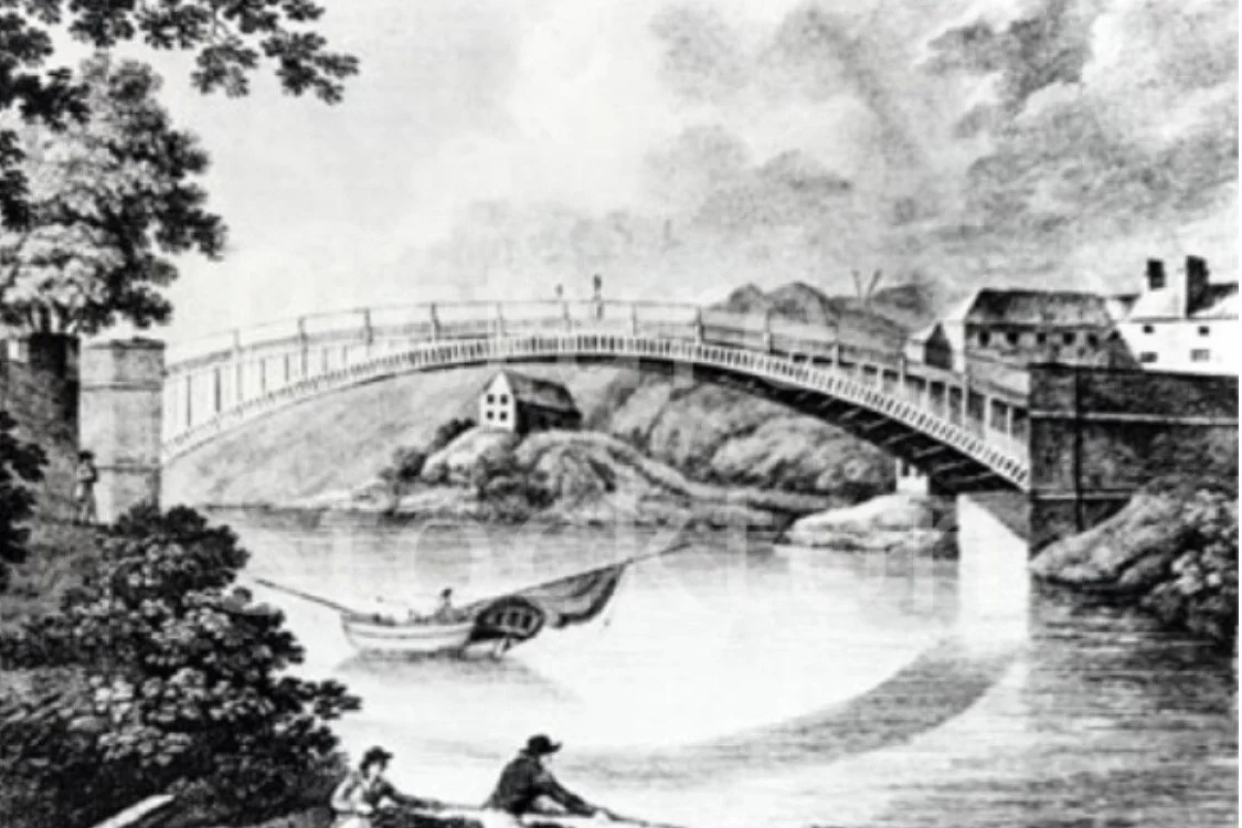
A sorry tale of Yarm’s Iron Bridge 1806
At about 12 midnight on 12th January 1806 the newly erected iron bridge over the River Tees at Yarm, fell with a tremendous crash and concussion that was felt over every part of the town.
This unfortunate accident came about supposedly owing to the abutments not having been built sufficiently strong to bear the weight of the arch, as they were not composed of solid stone but were chiefly filled with rubbish. It was the south abutment which gave way.
Fortunately the old bridge remained standing, as it still does today, or the road into that part of Durham must, at least for some time, have been totally stopped.
By the end of the 18th century, the stone bridge at Yarm, only 12 feet wide, was no longer felt to be adequate to cope with the increasing traffic. It was decided to replace it with a new single span iron bridge designed by the engineer responsible for the Wearmouth Bridge at Sunderland.
The new bridge was completed on 26th September 1805 and Richardson Ferrand, an ex Mayor of Stockton, with three or four other gentlemen visited it in an open post chaise carriage. When on the centre of the elegant new bridge they drank to the undertaking, with a bowl of punch, and proposed the toast "May the Almighty protect this undertaking. May this bridge stand the test of ages till time is no more."
During the construction work, in response to public pressure, there had been a change of plans. The bridge was raised four feet higher and this meant also raising the roadway for 100 yards on the Yarm side. The townspeople of Yarm refused to pay the additional £300 cost and the North Riding of Yorkshire couldn't levy a rate to cover the cost until the following year. So.......there was deadlock and indignation.
The deadlock was resolved in dramatic fashion when the £8,000 iron bridge fell into the river which, it was recorded, with a tremendous crash that shook the residents out of their beds. The shock was so great in the immediate neighbourhood, as to resemble that of an earthquake.
The south abutment had collapsed. A panel of architects appointed to enquire into the disaster blame principally the fact that the abutment, instead of being of solid masonry, had consisted of a masonry shell filled with rubbish. Workmen were employed in getting the iron out of the river, to prevent the town from being inundated in case of heavy rains.
~ info Tyne Mercury/Newcastle Courant/British Press dated 20th - 28th January 1806.